How to Locate Graves Underground
Contact us: e-mail geomodel@geomodel.com / 703-777-9788
How to Locate Graves - Introduction
One of the most efficient ways to locate unmarked or marked graves is to utilize ground penetrating radar (GPR). Ground penetrating radar is a non-intrusive method (does not require digging or probing) and is a fairly quick one for investigating large areas in a day, depending on the terrain and vegetation cover.
Ground penetrating radar (GPR) surveys are useful for locating graves by detecting the actual buried casket or vault, the burial trench, a void caused by a collapsed casket, and sometimes other objects, such as casket lowering apparatus. Ground penetrating radar is operated along the ground surface, and produces a cross-sectional image of the ground and caskets, as shown below.


How to Locate Graves - the GPR System and Field Procedures for a GPR Survey
A ground penetrating radar (GPR) system is comprised of the GPR digital field computer and the GPR transducer (antenna), connected by a cable. The GPR field computer can be attached to a harness and carried in front by one person, or the field computer can be attached to a GPR field cart and be pushed along by one person. The GPR antenna would either be pulled behind the person carrying the field computer or by another person, or the antenna could be mounted under the GPR field cart. The images below show some of the equipment used in a GPR survey to locate graves.


GeoModel, Inc. operator using the GPR computer harness and pulling a 400-MHz antenna in a cemetery (above left) and using the GPR field survey cart (above right).
GPR surveys for locating graves are efficiently conducted. The GPR antenna, whether pulled behind the operator, or mounted on the GPR field survey cart, is moved along the ground in one transect line, parallel to a cemetery row, and perpendicular to the long orientation of the graves (across the graves). After running one transect line, the operator then moves a short distance away from the first transect line (usually 2 to 3 feet) to collect another transect line of GPR data. This procedure is followed until the entire survey area is covered.
Collecting GPR profile data across (perpendicular to) a grave produces a more distinct response (an inverted U-shape) in the GPR profile that represents the top of the casket. Collecting GPR data in a direction parallel to the long side of the casket would produce a longer, flat-topped "anomaly" whose central location may not be as distinct.
How to Locate Graves - Interpretation of GPR Profile Data
After each GPR transect data is collected, the operator can replay it on the field computer in real-time or save the GPR profile data to the field computer to be interpreted later in the field or to be downloaded and processed back in the office. An example of GPR data showing marked and unmarked graves of various internment periods is shown below.
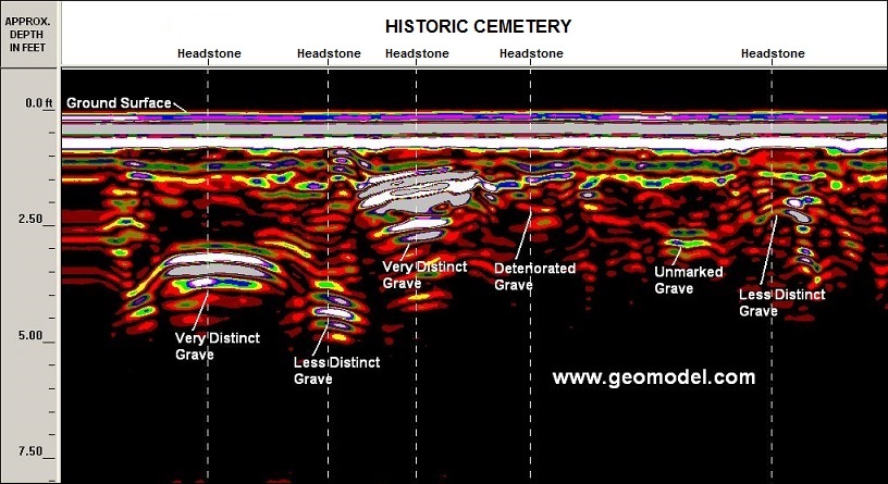
Recent internments (1 to 50 years old) produce very distinct grave anomalies in the GPR profile and are most easily detected. These recent graves are highly reflective and produce alternating white and gray bands of color. Older graves (50 to 100 years old or more) produce less distinct or minimal grave anomalies (less white and gray bands) and are more difficult to detect. Very deteriorated graves have fewer reflective surfaces and produce less distinct (yellow, red, blue or green) colors in the GPR data.
Besides the age of the graves, the type of soil in the gravesite area can determine the effectiveness of the GPR method to locate graves. Remains of burials are easier to locate in sandy soils that do not contain tree roots or stones. In clay soils, graves are more difficult to detect, especially below a depth of about 3 feet.
In cases where a vault or casket does not exist, or where the casket has completely deteriorated, the GPR data is examined for evidence of disturbed top soil, grave trenches, voids caused by collapse of the grave, or other indications of the burial, including any grave lowering apparatus left behind.
GeoModel, Inc. conducts GPR surveys for locating graves using a GPR digital control unit and an antenna with a frequency of 400-megaHertz (MHz). A 400-MHz antenna can examine the subsurface to depths of up to 8 feet in sandy soils, but less deep in clayey soils as shown in the example GPR profile above.
How to Locate Graves - Marking Locations of Graves on the Ground in Real-Time
The most expedient and least expensive way to provide the results of a GPR grave location survey is to mark the locations of the graves on the ground with paint or flags, while in the field.
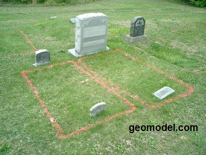
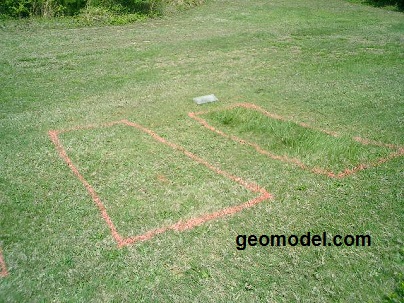
GeoModel, Inc. confirmed gravesites with headstones and footstones (above left) and located gravesites with minimal or no headstones (above right), by marking their locations on the ground with orange paint.
How to Locate Graves - Cemetery and Gravesite Mapping Surveys
In addition to marking the locations of gravesites on the ground with temporary paint marks or flags, locations of graves can be plotted on 2-D (plan view) site maps of the cemetery. To save money, the client could plot the locations of the graves on an in-house map or at additional cost retain a surveying company to produce a map of the grave locations.
Also, GeoModel, Inc. can conduct a gravesite mapping survey, for which we provide a site map (in AutoCAD or PDF) with the locations of the graves and headstones plotted on it. This in-office cemetery mapping service is provided at additional cost to field marking of graves.
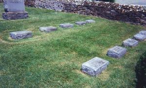
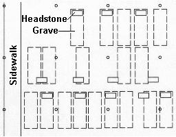
The cemetery map (above right) shows the results of a GeoModel, Inc. cemetery mapping survey in which grave locations are located in relation to headstones. Note that some of the graves don't necessarily match up with the headstones. In some cases, there is no headstone associated with the grave.
How to Locate Graves - 3-D Cemetery and Gravesite Visualization
In some special cases, 3-Dimensional imaging can be used to better define graves or provide impressive presentation visualizations. This process requires very close field spacing of GPR survey lines and computer processing using special 3-D software. The 3-D modeling works best in sandy soils and is at extra cost to a field marking survey or a 2-D AutoCAD mapping survey.
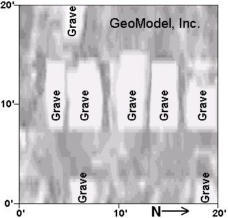
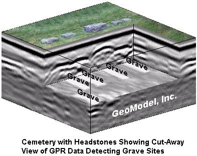
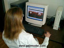
Three-dimensional GPR images, such as the one above, can be produced using raw field data and post-processing software. Below, a GeoModel, Inc. GPR data interpreter downloads, processes, the interprets the GPR data.
How to Locate Graves - Hire GeoModel, Inc. to Conduct a Grave Location Survey for You
GeoModel, Inc. was founded in 1991 as a geophysical services and environmental consulting firm. The company principals have over 50 years of combined experience and have conducted numerous cemetery grave location and other projects worldwide using ground penetrating radar (GPR).
All surveys are conducted or supervised by Certified Professional Geologists (PG)
GeoModel, Inc. in The News

GeoModel, Inc. has been in the news in Florida for our grave location surveys.
GeoModel, Inc. conducted a ground penetrating radar survey, at a cemetery in south Florida, to locate grave sites.
A local reporter took this photo as GeoModel, Inc. was conducting its survey. The story was covered in the local Sun Sentinel, Florida, newspaper.
For a ground penetrating radar survey to locate graves, click on your state below:
e-mail: ![]() geomodel@geomodel.com
geomodel@geomodel.com
 [Back to Top of Page][Back to GPR Applications]

